ICE STORM WARNING: Expect Power Outages, Travel Nearly Impossible
The National Weather Service says significant icing is expected across the Mid-South beginning later tonight and throughout Thursday. As much as a half inch of ice is expected. Click here to download the FREE KWAM NewsTalk app for breaking news updates. Following, is the warning:
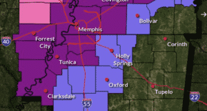
Forecast storm total sleet accumulations for the Mid-South for later tonight into Thursday evening. #tnwx #arwx #mowx #mswx #midsouthweather pic.twitter.com/OsOEYW08ZA
— NWS Memphis (@NWSMemphis) February 2, 2022
ICE STORM WARNING REMAINS IN EFFECT FROM MIDNIGHT TONIGHT TO
MIDNIGHT CST THURSDAY NIGHT…
* WHAT…Significant icing expected. Ice accumulations of one
quarter to one half inch. Total sleet and snow accumulations of
up to one inch.
* WHERE…Portions of North Mississippi and West Tennessee.
* WHEN…From midnight tonight to midnight CST Thursday night.
* IMPACTS…Power outages and tree damage are likely due to the
ice. Travel could be nearly impossible. The hazardous
conditions could impact the morning or evening commute.
PRECAUTIONARY/PREPAREDNESS ACTIONS…
Travel is strongly discouraged. If you must travel, keep extra
blankets, food, water and a flashlight in your vehicle in case of
an emergency. Prepare for possible power outages.
The latest road conditions for the state you are calling from can
be obtained by calling 5 1 1.
Categorized:Local News