ICE STORM WARNING!
An ice storm warning is in effect across the KWAM listening area. Our severe weather team has been activated and we will provide you with live coverage beginning at 6 a.m. Thursday on “Wake Up Memphis with Tim Van Horn.”
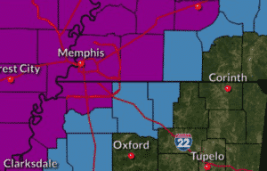
Be sure to check out our live radar on the KWAM weather page. Following is a bulletin from the National Weather Service in Memphis:
This hazardous weather outlook is for portions of East Arkansas...
the Missouri Bootheel...North Mississippi...and West Tennessee.

.DAY ONE...This Afternoon and Tonight

There is a threat for significant icing across portions of the
Mid-South tonight into Thursday. Ice accumulations may exceed one
quarter inch in the areas in the warned area. This will result in
hazardous travel concerns and damage to trees and power lines.

.DAYS TWO THROUGH SEVEN...Thursday through Tuesday

Freezing rain will continue into Thursday. Additional ice
accumulations will be possible.

Please refer to the latest forecasts in the coming days for
details regarding the evolution of the cold air surge and any
potential wintry weather.

Wind chill values may drop into the single digits along and north
of I-40 Friday morning and across much of the Mid-South Saturday
and Sunday mornings. Below zero wind chills are possible across
northern areas of the Mid-South Sunday morning.

Snow will be possible by early next week with accumulations
possible.
Categorized:Local News